Join the Hide community
Get access to live stream, lessons, the post exchange, and chat with other snipers.
Register
Download Gravity Ballistics
Get help to accurately calculate and scope your sniper rifle using real shooting data.

Install the app
How to install the app on iOS
Follow along with the video below to see how to install our site as a web app on your home screen.
Note: This feature may not be available in some browsers.
You are using an out of date browser. It may not display this or other websites correctly.
You should upgrade or use an alternative browser.
You should upgrade or use an alternative browser.
Fieldcraft pace beads
- Thread starter ubet
- Start date
Re: pace beads
When doing land nav, if you know how long your stride is, you can use your pace count to measure distance with a pretty impressive degree of accuracy. This is important when you have to travel around obstacles like lakes, cliffs, super dense brush, etc. Pace beads help you keep track of how many steps you've taken when you start getting into 10's 100's or even 1000's ala Rosary beads.
When doing land nav, if you know how long your stride is, you can use your pace count to measure distance with a pretty impressive degree of accuracy. This is important when you have to travel around obstacles like lakes, cliffs, super dense brush, etc. Pace beads help you keep track of how many steps you've taken when you start getting into 10's 100's or even 1000's ala Rosary beads.
Re: pace beads
However you navigate. Actually once you know your pace count for one distance, it is easy to compute it for other distances.
However you navigate. Actually once you know your pace count for one distance, it is easy to compute it for other distances.
Re: pace beads
Okay I'll give you a quick down and dirty.
100m, measured out. You pace that out, stepping off with whichever foot you want- the foot you step off with will be the foot that you count paces on... like so:
left
right
left (one)
right
left (two)
right
left (three)
Most pace counts on flat land are from the high 50's to mid 60's. Depends on the individual. Now comes in the pace count beads. For every 100m, you move one of the 9 beads. When you move the 9th bead, all the beads go back and you move one of the top beads (usually 4-6). Bottom beads track 100m intervals, top beads track 1km (1000m) intervals.
If you need more than the 4-6km capability of a standard set of pace beads, you're doing land nav wrong. It's always a good idea if you have to travel that far to start over when you get to a known point (example, where a river splits in two directions). Then continue your count from that location.
Get it?
Re: pace beads
Yes I use them always have . Some more good info here.
http://therucksack.tripod.com/landnav.htm
Yes I use them always have . Some more good info here.
http://therucksack.tripod.com/landnav.htm
Re: pace beads
For what it's worth, I only found them useful on moonless nights / other situations where you're relying on dead reckoning.
Terrain association always worked better for me.
But it's been a long long time since I was tromping in the woods.
For what it's worth, I only found them useful on moonless nights / other situations where you're relying on dead reckoning.
Terrain association always worked better for me.
But it's been a long long time since I was tromping in the woods.
Re: pace beads
use the method dp425 described , only thing i do different is i only have 10 beads on the paracord, when iv moved all 10 iv humped a km. i dont use a seperate set for counting km .if you use them in conjuction with naismiths rule and you are now tracking your progress with both your pace counting and your time you have been humping you should keep a pretty accurate idea of your distance covered. as former0302 said terrain association allways works better but pace beads can help on very dark nights or very barren /open featureless ground
use the method dp425 described , only thing i do different is i only have 10 beads on the paracord, when iv moved all 10 iv humped a km. i dont use a seperate set for counting km .if you use them in conjuction with naismiths rule and you are now tracking your progress with both your pace counting and your time you have been humping you should keep a pretty accurate idea of your distance covered. as former0302 said terrain association allways works better but pace beads can help on very dark nights or very barren /open featureless ground
Re: pace beads
DP425 has good info on how to actually use them. They're good for beginners but most grunts I know quickly grew out of them with experience.
One thing to watch out for on pace count beads is if you're in dense brush. They tend to get snagged and will throw off your pace count. A better method to use in brush is rocks/sticks in a pocket or pouch. Pick them up or transfer them from pouch to pouch in the same manner, and you can use small and large together for different increments.
That being said, I never liked them at all and would use notes on my map or patrol log instead if I really needed to. Terrain association, constant map checks and markings, attack points and a good overall sense of direction and distance were always how I made it to the objective. I never kept pace count except when I was on an actual land nav course looking for a camouflaged box hidden in the middle of a dense bush, and even then the map and terrain was my best friend, not some beads.
Re: pace beads
What everyone after me has said are VERY valid points. On LRS teams, we always have two guys running pace count, I can't remember anyone but the new guys (who aren't even on the teams yet- selection and training section) using them. But anyway, between two guys running pace count (scout and senior scout, and often times the TL) and using terrain association, you really should never get lost. Worthy to note is, you should never rely on a single method, or on one person conducting the patrol. Always have a back-up to your back-up, and be sure everyone else is tracking on location at all long halts. Everyone should already know the planned routes and points anyway, so it's only a matter of tracking progress for everyone else.
Of course, that is assuming you are not unfortunate enough to have a few idiots with you. Not everywhere can you vet and kick out the retards. They just better hope there isn't a break in contact!
Re: pace beads
Thanks for all the info.
My next question, on using degrees, dd.mm.ss.s type of plotting (?). How do I read these on a topo? I am at my house, I have the long/lat. On a topo, I see in the corners where it gives you the dd.mm.ss.s BUT, I cant figure out which lines break it up evenly. On the topo I have their is an 8 minute spread on the Lat, and their are two marks one that says Im looking at 39.37N top of the map is 39.45. In between those their are two correlating numbers 40' and 42'30". ON these maps, their are blue ticks that are on both sides of the edge of the map, black lines that are on both sides of the edge of the map, then a black line that sits on the inside edge of the map. They are usfs topo quadrants. Which lines are the ones that declare the minutes? Am I totally fubared on this?
Re: pace beads
I am pretty good at remembering how to get out of a place, if I have gotten myself in there. But have never followed it exactly on a map, never really used a map intricately before, but want to learn the basics. Thanks for any advice
I am pretty good at remembering how to get out of a place, if I have gotten myself in there. But have never followed it exactly on a map, never really used a map intricately before, but want to learn the basics. Thanks for any advice
Re: pace beads
I was at HuckleBerry Creek in 1985 and one of the Ranger instructors suggested the beads.
So I made a cool set.
And they are as brand new looking today as they were when I made them.
I got too distracted trying to remember to move a bead, and "Did I MOVE a bead on the last 100m or not???"
Nowdays you can carry a GPS.
BUT in the event that fails, it's like DP425 said in both of his posts. Nobody uses them (Normally).
I think I had one REALLY intense land nav test I had to do so I used them.
They were more fun to make and have as a cool thing.
Funny, I'd forgotten about that set of beads...
Re: pace beads
never much liked the anal bead strings, they always seemed to get hung up on branches and stuff and threw me off. So Im high speed and do old school trickery of putting a pebble in my pocket every 100 meters, then count the pebbles to see how far ive gone. yes ghetto but its worked for me
on the lat/long question I have no clue, I'm an MGRS type O' guy
Re: pace beads
<div class="ubbcode-block"><div class="ubbcode-header">Originally Posted By: VAJayJayPunisher</div><div class="ubbcode-body">on the lat/long question I have no clue, I'm an MGRS type O' guy</div></div> Pretty much same for me. What I have done though is use a piece of paper and ruler to draw up a makeshift protractor for them, or just eyeball dissect it similar to a mildot reticle to get me close enough.
That's the problem with lat/long; there is no standard distance for degree to degree throughout the earth, especially when plotting longitudes when you get to the far northern/southern latitudes. Then you need a different scale from the top to bottom of your map. A real PITA....
Any sailors/pilots/surveyors around that can chime in on this one? I'd be interested to hear some suggestions myself.
Re: pace beads
This topic brings back some great memories. I remember asking that question 35 some odd years ago. I spent a great deal of time in the Alaska Natonal Gurad Light Recon Detachment (Abn).
Now, about beads, knots in on a string, pebbles, what ever. Try that on skis. The below picture dosn't reflect it, but in Western Alaska, there is few terian features, you can't pace with skis. All you have is flat blowing snow.
The saving grace is you had more darkness then light, you learned to use stars. You'd be supprise how close you can come. There was always a village or something close to your objective had once close, the lights fron those objects would get you on target.
This was before the days of GPS.
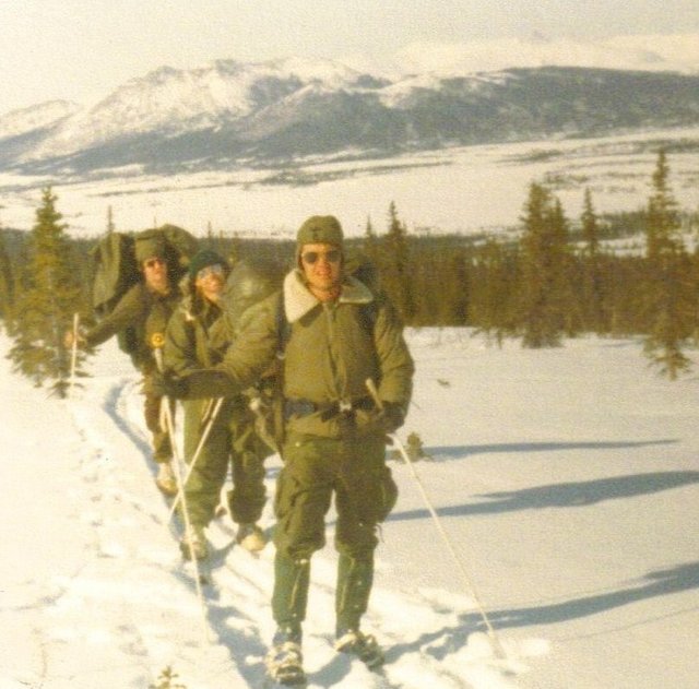
Re: pace beads
Beads... never used them. I guess I could it see if the terrain was reasonable. I have just never used them and don't see them as that useful on a lot of the terrain around here. Today I was covering terrain that was stupid steep, rocky, and brushy. The stride was 1/3 of normal at best. The only way to get stability while walking side hill meant walking like a duck - do my best to point the down hill foot more with the fall line, try and point the up hill foot toward the crest.
Here is great book on Land Nav - GPS Land Navigation. It covers how to really use your GPS / how to set up, read, fold, completely understand a USGS 7.5 minute map / Compass work / Pace Beads - and so much more.
Good luck
Re: pace beads
mozambeek, thanks. Will have to look at that!
Artic, thats a damn cool (cold) picture.
mozambeek, thanks. Will have to look at that!
Artic, thats a damn cool (cold) picture.
Re: pace beads
I have been doing a lot of reading on maps, and have started to figure out UTM grids. They seem a lot easier and more straight forward than lat and long
I have been doing a lot of reading on maps, and have started to figure out UTM grids. They seem a lot easier and more straight forward than lat and long
Re: pace beads
Pace beads are a good tool but as stated before they can be moved on accident. So some say to pick up a pebbel and use that, but they can fall out and they add weight and can dig in to you. A much better method is to tie a not in a strand of cord for every unit of measure you like. They will always be there when you really need them. I would also recomend if you are competeing in a orienteering course verify your pace in the AO and adjust it accordingly. As stated before dence brush can through your pace off as can deep sand or mud and even steep elevation. Just some thoughts.
Pace beads are a good tool but as stated before they can be moved on accident. So some say to pick up a pebbel and use that, but they can fall out and they add weight and can dig in to you. A much better method is to tie a not in a strand of cord for every unit of measure you like. They will always be there when you really need them. I would also recomend if you are competeing in a orienteering course verify your pace in the AO and adjust it accordingly. As stated before dence brush can through your pace off as can deep sand or mud and even steep elevation. Just some thoughts.
Re: pace beads
<div class="ubbcode-block"><div class="ubbcode-header">Quote:</div><div class="ubbcode-body">http://therucksack.tripod.com/landnav.htm
 </div></div>
This is a good source.
Special Forces is among the organizations where individual day and night movements over ignorant distances and terrain are used as a Selection tool.
Learn your pace clean (field clothing or street clothes) and encumbered (rifle with body armor and fighting kit or web gear and rucksack) -- your pace will definitely be different. You'll also need to modify when you're on rough terrain or in heavy brush. 2 men keeping pace is an excellent technique.
Beads work well. Keep your pace by kilometer and switch over again as you cover a click. I've never been able to keep track of rocks and pebbles, especially at night or in the desert -- I don't want to break stride to bend down and pick shit up
Not too long ago I was setting up paper targets with a youngster before pounding steel farther out and he asked, "How do you know that's a hundred Meters?"
We walked back to the truck and lased it with a PLRF-10. 100 Meters on the nose.
<div class="ubbcode-block"><div class="ubbcode-header">Quote:</div><div class="ubbcode-body">http://therucksack.tripod.com/landnav.htm
This is a good source.
Special Forces is among the organizations where individual day and night movements over ignorant distances and terrain are used as a Selection tool.
Learn your pace clean (field clothing or street clothes) and encumbered (rifle with body armor and fighting kit or web gear and rucksack) -- your pace will definitely be different. You'll also need to modify when you're on rough terrain or in heavy brush. 2 men keeping pace is an excellent technique.
Beads work well. Keep your pace by kilometer and switch over again as you cover a click. I've never been able to keep track of rocks and pebbles, especially at night or in the desert -- I don't want to break stride to bend down and pick shit up
Not too long ago I was setting up paper targets with a youngster before pounding steel farther out and he asked, "How do you know that's a hundred Meters?"
We walked back to the truck and lased it with a PLRF-10. 100 Meters on the nose.
Similar threads
- Replies
- 5
- Views
- 330