Range Card Advice

D1gger

GDI
Full Member
Minuteman
Supporter
  • Nov 12, 2017
    607
    419
    Staunton, VA
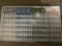
    Need some help/advice as to how to set up my range card for a Mammoth/Vortex type match. What I have done in the past is pre-print some cards with ranges from 400-1150 in 50yd increments, then have wind calls for 4, 8, 12 & 15 mph.
    It didn't really work great for me, so I'm looking for suggestions.
    I generally run a secondary rifle in 5.56, if that helps. I may take the primary going forward with a 6.5CM in the future.
    Any advice will be appreciated!
     
    I go 40 from 150-400, then 20’s to 1000m, anything after I’d have to dig I for the kestrel.

    Wind I hate a bunch of wind brackets. I do my base short wind and indicate which meter line they bump at. Considering all those matches are East and the winds are small I’d reduce wind data.

    You can make a wind cheat sheet for the back or inside your QB sleeve.
     
    @D1gger I’m curious as to what did not work out for you? I’ve shot several matches with a range card exactly how you described it. If the range came back between the 50y increments then I simple split the difference in the dope.
    So I'm fairly new to the range card. Most of my shooting is at known distances. I just want to verify that I'm not going down a road to nowhere. I probably do have too many wind brackets. I'm going to adjust it slightly and see how it goes.
    Thanks
     
    You're going down the right road. Keep playing with how to organize it then just practice using it. Color coding the elevation helps to not get lost in the wind values. Here's my range card from GTI. Being 6.5CM, the gap in values are smaller but would still use a similar concept for 223. Looking at my 223 data, I would go every 25 yards past 600 as the gap between is larger.

    Example: target comes back 714yd, I would dail 4.3. I most scenario being off by a tenth of a mil will still be an impact on a plate.

    1637246753965.png
     
    • Like
    Reactions: Darkside-Six
    Mine goes from 300-800 in 20 yd increments, with a column for 10 mph with a 6 mph gun. Beyond 800, I'm going to use a solver to get a firing solution.
     
    • Like
    Reactions: D1gger
    Whether or not you even have a Tremor3 in your rifle scope, you can do a print off for it, calibrate your printed wind dots with a Modern Windrose and your gun's windage data, and use it for a fast reference with the wind dots. I print out my dope before matches in 10yd increments and have them in a fanny pack and write my data on a Cole-Tac cheat sheet.

    I think there are cleaner options referenced by other users in this thread, but I figured I toss it out as an option.
     
    For UKD Matches, the 2 fastest ways to get data are to memorize it, or have the rangefinder spit it out.

    I typically can easily memorize 100 yard increments to 1000. Past that, I'm using a calculator. A lot of times .1 mil per ten yards will get you within a click with the odd jump here or there. (Which corrects itself every 100 yards if you memorize those values) If you have trouble remembering, write down every 100 yards and break it down from there.

    Learn the bc method of calling wind. Once you get a feel for it you can guess most times within 1 click and almost always within 2 clicks. That's better than most people can actually call the wind in mph.

    The other easy option is to buy rangefinding binos with ballistics and run those.
     
    You're going down the right road. Keep playing with how to organize it then just practice using it. Color coding the elevation helps to not get lost in the wind values. Here's my range card from GTI. Being 6.5CM, the gap in values are smaller but would still use a similar concept for 223. Looking at my 223 data, I would go every 25 yards past 600 as the gap between is larger.

    Example: target comes back 714yd, I would dail 4.3. I most scenario being off by a tenth of a mil will still be an impact on a plate.

    View attachment 7742949
    I run a card very similar to this but only one wind call..... don't over complicate this, what good does having a 6&12 on this example do other than show you it's exactly double?

    Give me one wind value like 10 MPH and I can break is down into 5 & 15 pretty quick that will do the same thing and save some space for more elevation data.

    Instead you could use the extra space to break down elevation into 25 yd increments
     

    Attachments

    • E9757E18-A53F-4918-AD36-934062992A9A.jpeg
      E9757E18-A53F-4918-AD36-934062992A9A.jpeg
      296.8 KB · Views: 127
    • Like
    Reactions: Darkside-Six
    What about something like this?

    Each blue line is 100 yards

    Each green line is wind speed in 10 MHP increments.

    Each yellow line is 1 MOA and each purple line is 5 MOA.

    The red line is spin drift.

    Scaling is for MOA not mils.

    Spending most of my time in F Class I have a habit of wanting to plot and analyze my shots. That works fine when shooting 12 shots from a fixed distance, but it does not translate well to PRS with multiple targets.

    That's what this format was developed for....

    During prep, I could hand draw a line parallel to the blue line indicating each target distance, then a small vertical before the stage showing my base wind call.

    After the stage I could plot where I thought my hits and misses impacted relative to my original plot. That provides a base line for analsys of what worked or did not.

    It would be real nice if a buddy on glass plots the shot impact relative to my plotted point of aim.

    Just print one page per stage and then have a complete record.

    1637723303388-png.7746716
     
    Last edited:
    I run a card very similar to this but only one wind call..... don't over complicate this, what good does having a 6&12 on this example do other than show you it's exactly double?

    Give me one wind value like 10 MPH and I can break is down into 5 & 15 pretty quick that will do the same thing and save some space for more elevation data.

    Instead you could use the extra space to break down elevation into 25 yd increments
    Do you have an editable version of your card that you would be willing to share?
     
    • Like
    Reactions: Darkside-Six
    Do you have an editable version of your card that you would be willing to share?
    Loaded it into the attached .zip file......I've got it set up to accept a copy paste from the shooter ballistic app, with tabs for each DA in 1k' elevation increments plus lots of other handy reference cards like MIL ranging and slope adjustment etc.

    I paste the data into PowerPoint and scale 3x5 with 4 cards per sheet and can built a complete set of cards in less time than it takes to type this post!
     

    Attachments

    • 25 Creedmoor-131 ACE .350BC @ 2,950.zip
      732.4 KB · Views: 130
    i make these and then laminate them. then just write over the laminate with a grease pencil. i carry several blank ones that i can just write out for different DA's. can also write my actual target on the reticle for different holds which works well.

    1643298219649.png
     
    The simplest and most universal is to cover the turret with your own BDC and wind comp label like these.

    The hardest part is designing it to scale but its easy enough even in MS Paint. Make it like 200 percent of intended size but print to 50 percent for finer pixels.

    The elevation is obvious but the wind is a little more abstract.

    The 2, 4, 6, 8, 1 represent the distance 200, 400, 600, 800 and 1000 for a 10 MPH cross wind.

    Everything you need to know is here for the base line atmospherics.

    If its cold come up an additional click or two and if its hot, come down one or two.

    For a 10 MPH full value crosswind just dial to the distance or thereabouts.

    For a 5 MPH full value wind go to half the MOA value of the 10 MPH wind

    For a 10 MPH half value wind go to half the MOA value of the 10 MPH wind

    The nice thing about this is everything you need to do the math is right here on the rifle.

    The limitation is your ability to translate to out of base line atmospherics like significant elevation changes. You still need to have a relative frame of reference for that.

    1643398248693.png