Drop Charts

Will be soon.

Shot various ranges out just past 1000 yards at 4500ft yesterday, trued the app/program to what I shot in the field. and then printed it out, changed the altitude from the trued program for the other pages...
 
How is that correcting for ammo tempature/powder burn rate?! Bet you need a chart to refer to with logged muzzle velocities at different tempatures otherwise you will have misses.
 
I use the same software and its very intuitive. As for ammo temp and burn rate, that would be more in the area of single based vs double based powder and temp stability. The software will spit out several types of prints, a very defined drop chart for a tweaked load, and a grab and go field chart that has temps in a 40 degree ambiant temp spread(for DA). So if you hunt in the morning around base camp , then move up to the top shelves by noon etc.

You can save area profiles in G7 i/e Chaffee range, Pawnee, Douglas WY, Houston TX and just use a drop down menu to spit out the atmospherics of the dope you got last time. Make any adjustments or just print out another field card.

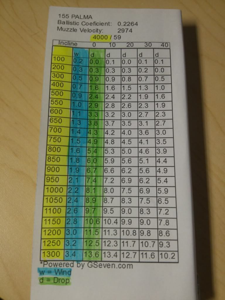
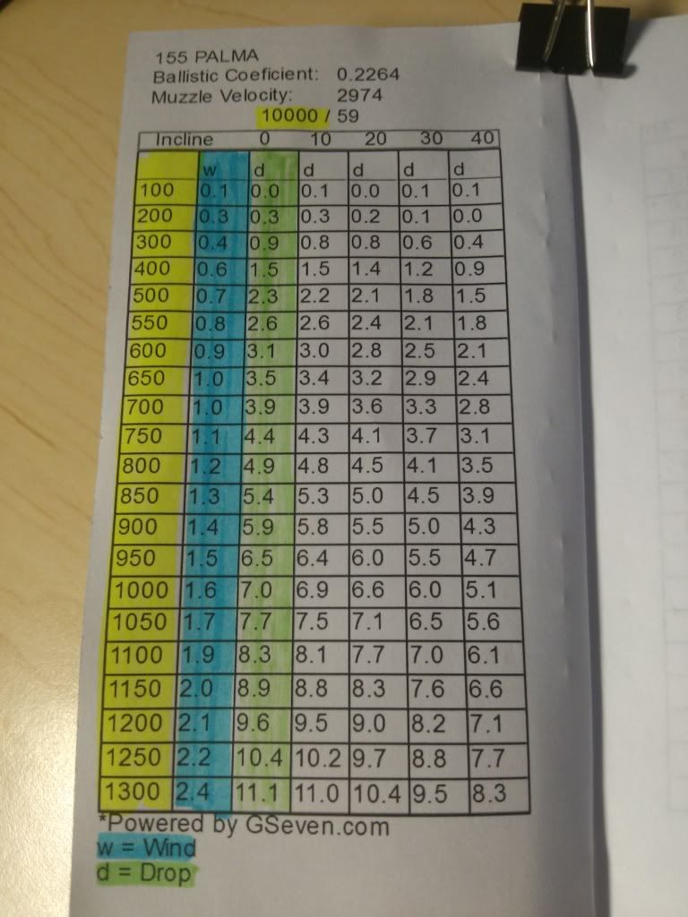
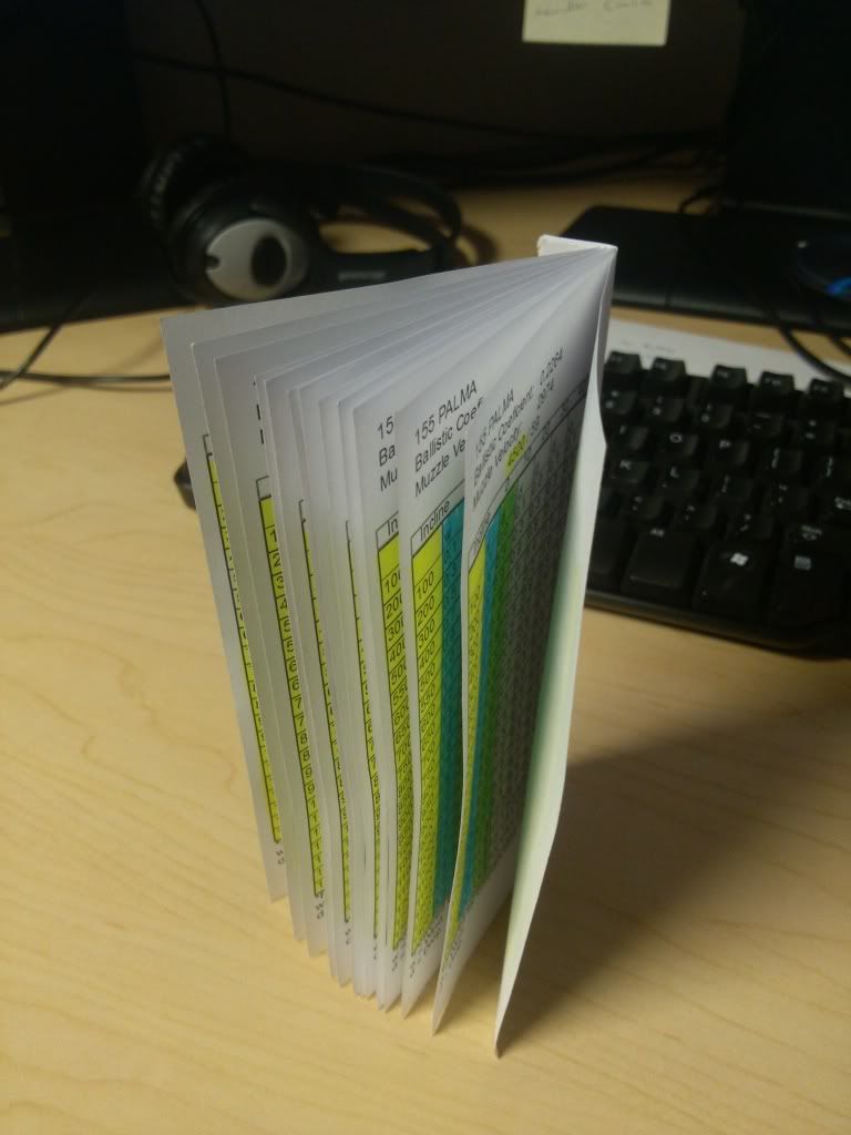
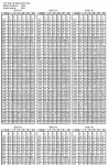
Here is a simple load I have and partial prints. One is a page similar to the Vortex version and the other is the field card/page. The pics are only screen caps, but you all should get the idea.
 

Attachments

  • Screen Shot 2013-06-14 at 3.12.54 PM.jpg
    Screen Shot 2013-06-14 at 3.12.54 PM.jpg
    75.9 KB · Views: 17
  • Screen Shot 2013-06-14 at 3.13.46 PM.jpg
    Screen Shot 2013-06-14 at 3.13.46 PM.jpg
    78.3 KB · Views: 17
Last edited:
I have to give it a try yet, but first impressions; these dropcharts are based on altitude....personally i favour drop charts based on density altitudes, since they give more accurate real world drop data.

A drop chart for 10.000feet is nice, but how accurate is it going to be when tomorrow the temp or pressure or even moist is different than today at the same elevation?

Just wondering if these kind of calculations are also possible with the mentioned site programm?
 
The drop charts are the output, go to the website and give it a spin. gseven - Ballistic Program

if you look at the first pic I posted, it has all of the atmospherics, simple gui drop downs to change altitude, temp, humidity , pressure wind etc.

Now the only thing is they do not have an Apple or Android interface as of yet. So this would be a laptop or home pc type of thing and just go out and obtain dope.

The cool thing is all of your data is stored on their server, so no matter where you are, if you can get a signal you have access to your drop charts.

Once the smartphone app is out, changes like DA can be done instantly.

The software may not be for everyone, but it is very easy to use, and they have an extensive library of bullets in G1 and G7, and loaded ammo.