I'm not a survivalist, but I am curious what it would take and the how to of long range shooting without electronics of any sort. Might come in handy one day? Is there a guide regarding the unpowered devices people would need to get all of the atmospheric info needed and how to develop paper ballistics charts for different conditions?
Join the Hide community
Get access to live stream, lessons, the post exchange, and chat with other snipers.
Register
Download Gravity Ballistics
Get help to accurately calculate and scope your sniper rifle using real shooting data.

Install the app
How to install the app on iOS
Follow along with the video below to see how to install our site as a web app on your home screen.
Note: This feature may not be available in some browsers.
You are using an out of date browser. It may not display this or other websites correctly.
You should upgrade or use an alternative browser.
You should upgrade or use an alternative browser.
unpowered devices and charts, etc.
- Thread starter pewpewfever
- Start date
Learning to read the wind, Range time, recording your data an DA each time will allow a plotted curve to be made. Stick with one load/bullet an forget about the rest of the B/S. (unless you also shoot subs from that gun) You shoot same/both long enough you will not need a book at all if/when it gets real. Also learn the hold points in your ret. If your shooting a SFP scope, know your holds at lowest power, 2x ret subtention power, an max power.
I shoot subs all the time on 3.5X (lowest setting) to 250-300 yds with no issues at all hitting a 6" target.
One gun will get you way down the road if you know how to use it quickly, an efficiently. If it's a SHFT event most everything will be 700-800 an in, get to where those are a give me an worry about the more important stuff, like food/water, medical, an being dry.

Density Altitude charts tailored to your loads is all you need.I'm not a survivalist, but I am curious what it would take and the how to of long range shooting without electronics of any sort. Might come in handy one day? Is there a guide regarding the unpowered devices people would need to get all of the atmospheric info needed and how to develop paper ballistics charts for different conditions?
So you don’t need to account for temperature or humidity? My ballistics calculator seems to take those into account, but I don’t know how significant a difference they make. An analog barometer/altimeter is an easy enough instrument to find. I’m still crutching on a windmeter while developing my wind reading skills. Are there analog wind meters available? Not having much luck searching for one. But I imagine I could take a page out of the Native American playbook and suspend different types of feathers from my weapon, and record what they do at different wind speeds.
No, because DA has wrapped both in. It's the best all-around solution for a paper chart, just make sure the different DA values are enough to match your conditions (enough columns)So you don’t need to account for temperature or humidity?
DA may be too complicated if you don't have power. How about, if you plan on being in the same area that you practice, you'll have a good idea of the altitude you'll be operating. This will define the air pressure. Weather changes are generally small variation in air pressure. Then your paper come-ups/wind will depend on temperature. Define the range of temperatures you'll be operating in and print out come-up/wind correction for every 10 to 20 degrees. Play with the temperature increment to see where large steps in correction occur.
I like to plug in a full value wind of 10 mph. Then you can scale from this value. If the wind is actually 5 mph then you take half the value. If the wind is coming from 1 o'clock you can take half the value.
Humidity has very little affect on air density. More humidity means less air density.
I like to plug in a full value wind of 10 mph. Then you can scale from this value. If the wind is actually 5 mph then you take half the value. If the wind is coming from 1 o'clock you can take half the value.
Humidity has very little affect on air density. More humidity means less air density.
Of course DA "altitude" is not your current altitude, but is usually close enough if you do your homework. Now, guessing temp, etc. is another game. Any map with altitude curves should give you enough "data" for good shots at medium ranges (say 500/600 yds) beyond that you should stop guessing about the current met conditions and get yourself some kind of instrumental readings.DA may be too complicated if you don't have power. How about, if you plan on being in the same area that you practice, you'll have a good idea of the altitude you'll be operating. This will define the air pressure. Weather changes are generally small variation in air pressure. Then your paper come-ups/wind will depend on temperature. Define the range of temperatures you'll be operating in and print out come-up/wind correction for every 10 to 20 degrees. Play with the temperature increment to see where large steps in correction occur.
I like to plug in a full value wind of 10 mph. Then you can scale from this value. If the wind is actually 5 mph then you take half the value. If the wind is coming from 1 o'clock you can take half the value.
Humidity has very little affect on air density. More humidity means less air density.
So you travel out of state for a match where you’ve never shot and don’t know the altitude off the top of your head. It’s so far from civilation that there’s no cell service, and the long predicted solar flare that takes out all the satellites hits. Plus, the nonrechargeable battery in your kestrel dies or it gets broken or stolen. What do you need to compete at 1000 yards plus? A barometric altimeter, thermometer, humidistat, and a fat binder of charts already filled out with data from your ballistics calculator using many combinations of conditions? What do you use to measure angle if inclination or declination? A protractor with a level indicator?
So you travel out of state for a match where you’ve never shot and don’t know the altitude off the top of your head. It’s so far from civilation that there’s no cell service, and the long predicted solar flare that takes out all the satellites hits. Plus, the nonrechargeable battery in your kestrel dies or it gets broken or stolen. What do you need to compete at 1000 yards plus? A barometric altimeter, thermometer, humidistat, and a fat binder of charts already filled out with data from your ballistics calculator using many combinations of conditions? What do you use to measure angle if inclination or declination? A protractor with a level indicator?
Okay, I think I understand. You're an ultimate preper. Uh-huh, just get a few of each of those instruments, charts to estimate Density Altitude, and then come-up/wind correction tables for various Density Altitude from -5000 to 20,000 feet. Yeah, that should do it. ;-)
Map contour lines will tell me the altitude, add a simple thermometer, + the barometric pressure gauge built into my VX6R, will get me close enough for most real engagements.
So you travel out of state for a match where you’ve never shot and don’t know the altitude off the top of your head. It’s so far from civilation that there’s no cell service, and the long predicted solar flare that takes out all the satellites hits. Plus, the nonrechargeable battery in your kestrel dies or it gets broken or stolen. What do you need to compete at 1000 yards plus? A barometric altimeter, thermometer, humidistat, and a fat binder of charts already filled out with data from your ballistics calculator using many combinations of conditions? What do you use to measure angle if inclination or declination? A protractor with a level indicator?

D
Deleted member 113831
Guest
Out to about 600 yards, none of this matters except for wind and slope, and it would take a pretty dramatic slope at 600 to make a meaningful difference.So you travel out of state for a match where you’ve never shot and don’t know the altitude off the top of your head. It’s so far from civilation that there’s no cell service, and the long predicted solar flare that takes out all the satellites hits. Plus, the nonrechargeable battery in your kestrel dies or it gets broken or stolen. What do you need to compete at 1000 yards plus? A barometric altimeter, thermometer, humidistat, and a fat binder of charts already filled out with data from your ballistics calculator using many combinations of conditions? What do you use to measure angle if inclination or declination? A protractor with a level indicator?
Make your charts using absolute pressure and temp. Know what your change per 2 inHg is, and know what your change per 20*F is for each range. Add and subtract the two as necessary.
Buy a solar powered G-Shock watch that is capable of giving absolute pressure. If it didn't survive whatever calamity there happened to be, then you probably didn't either. Failing that, a topo map of the area of operations should give you your altitude.
Buy a cheap simple Kestrel and live with it until you learn wind and have it in your brain. Then you won't need it.
You should be able to guess temp within 5 degrees with a little practice. Failing that, a cheap keychain thermometer will do the trick.
None of this shit is hard, it just takes methodical practice and weeding out stupid shit that doesn't matter.
Last edited by a moderator:
For measuring inclination and declination, a Suunto clinometer is invaluable. I use one in target archery, getting a hard and accurate reading rather than relying on an electronic device to get you close is extremely useful, especially for yardage cuts.
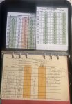
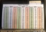
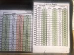
For the rest, print off some charts, maybe more than some, and go shoot and verify. Shoot in the worst and best weather you can find, different altitudes, temps, wind, etc.
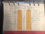
There’s really no way around verifying your dope cards other than sending bullets downrange. It either hits or it doesn’t. I’ve always just printed off a good number of them using JBM to get a range of cards, found the ones that line up best, clearly label and laminate. Do the same for every new locale you can shoot in, and be sure to record all pertinent info.
Used to be, you’d see shooters with dope cards taped to their rifles, and that was the norm. There are other ways to do everything, this is just what I did/do.
Ballistic computers have made this stuff a hell of a lot easier.
For the rest, print off some charts, maybe more than some, and go shoot and verify. Shoot in the worst and best weather you can find, different altitudes, temps, wind, etc.
There’s really no way around verifying your dope cards other than sending bullets downrange. It either hits or it doesn’t. I’ve always just printed off a good number of them using JBM to get a range of cards, found the ones that line up best, clearly label and laminate. Do the same for every new locale you can shoot in, and be sure to record all pertinent info.
Used to be, you’d see shooters with dope cards taped to their rifles, and that was the norm. There are other ways to do everything, this is just what I did/do.
Ballistic computers have made this stuff a hell of a lot easier.
For club matches I use a dope card that has multiple elevations and temps. I created it in JBM use trued data for one elevation and temp. I keep updating with actual dope over time for other elevations and temps. For bigger matches I’ll creat a custom card based on actual predicted weather.
I keep a wind chart for different mph guns in MOA &MIL helps if calling wind for others.
I keep a wind chart for different mph guns in MOA &MIL helps if calling wind for others.
Attachments
Horus makes an analog inclinometer that attaches to a scope (Horus Vision ASLI), and Nightforce makes one that attaches to a rail (Nightforce Angle Degree Indicator A122).
Well, before you start worrying about the atmospherics you better learn how to range using your reticle. Then develop wind reading skills, after those two you can pull out the thermometer, charts and slide-rule and have at it.
^ this!!!
Ranging and wind reading are going to be way bigger sources of error for most shots than temperature and angle.
Ranging and wind reading are going to be way bigger sources of error for most shots than temperature and angle.
JBM - Calculations
 www.jbmballistics.com
Run your data in this. It will take some editing in a spreadsheet, but if you are dead set on your cartridge/load do a DA card in 3k increments as well as 20 degree temperature increments.
For example, you'd have a DA card for 3000DA and have the data seperated in a column for 60/80/100/120 degrees (or whatever, depending where you are and expecting the temperate range to be).
Format. Print. Laminate.
For cosine, I wouldn't worry about it unless youre shooting high angle a lot. For wind, well, learn to read the mirage as well as get out there and practice what bracket speeds of wind feel like.
ETA - Looks like TimetoShoot has the same thing going.
So you travel out of state for a match where you’ve never shot and don’t know the altitude off the top of your head. It’s so far from civilation that there’s no cell service, and the long predicted solar flare that takes out all the satellites hits. Plus, the nonrechargeable battery in your kestrel dies or it gets broken or stolen. What do you need to compete at 1000 yards plus? A barometric altimeter, thermometer, humidistat, and a fat binder of charts already filled out with data from your ballistics calculator using many combinations of conditions? What do you use to measure angle if inclination or declination? A protractor with a level indicator?
You sound like the typical millennial who wants to have all his questions answered without putting in the work. Go shoot and learn this shit the hard way.
I don't have, and never have used, any electronics in the field or the range to get my solution and my hit percentage is as good or better than those I shoot with that use that stuff.
You sound like the typical millennial who wants to have all HER questions answered without putting in the work.
Hi,
Fixed it for you, lol.
Sincerely,
Theis
When ranging a target a ASLI is important to prevent missed shots.
While you range a target say at 700 yds, that is line of sight. Now consider the cosine angle says .8 degrees above your position for simplicity. The true range changes. 700 yds. multiplied by .8 equals actually 560 yds. This is why most new shooters and some old shooters overshoot most angled shots over 500 yds. I have Horus ASLI on all my optics for that reason. I will admit gen one was easier to read before the changing of ownership. Version two I just put on my B.E.A.S.T. and not as easy to read. Still highly reccomend for any serious shooters. I own three for that reason and all scope mounted not rail. The reason is if I move a scope to another firearm it is all ready level with the recital. Hope you enjoy the read and no I am not employed nor do I have any connections with Horus Vision
While you range a target say at 700 yds, that is line of sight. Now consider the cosine angle says .8 degrees above your position for simplicity. The true range changes. 700 yds. multiplied by .8 equals actually 560 yds. This is why most new shooters and some old shooters overshoot most angled shots over 500 yds. I have Horus ASLI on all my optics for that reason. I will admit gen one was easier to read before the changing of ownership. Version two I just put on my B.E.A.S.T. and not as easy to read. Still highly reccomend for any serious shooters. I own three for that reason and all scope mounted not rail. The reason is if I move a scope to another firearm it is all ready level with the recital. Hope you enjoy the read and no I am not employed nor do I have any connections with Horus Vision
Attachments
Last edited:
My data book says different for only a 8* even shooting the out dated 308/175smkWhen ranging a target a ASLI is important to prevent missed shots.
While you range a target say at 700 yds, that is line of sight. Now consider the angle say 8 degrees above your position for simplicity. The true range changes. 700 yds. multiplied by .8 equals actually 560 yds. This is why most new shooters and some old shooters overshoot most angled shots over 500 yds. I have Horus ASLI on all my optics for that reason. I will admit gen one was easier to read before the changing of ownership. Version two I just put on my B.E.A.S.T. and not as easy to read. Still highly reccomend for any serious shooters. I own three for that reason and all scope mounted not rail. The reason is if I move a scope to another firearm it is all ready level with the recital. Hope you enjoy the read and no I am not employed nor do I have any connections with Horus Vision
You are correct, I neglected to site cosine instead of angle in degrees. I since have revised my post and thank you for pointing out my error.
You are correct, I neglected to site cosine instead of angle in degrees. I since have revised my post and thank you for pointing out my error.
Yep. That’s about 37 degrees.
My Sig Sauer KILO2200MR LaserRangeFndr7X25GraphClass3R has the AB solver built in to give me horizontal range. It’s quite the crutch though. I need to develop reticle ranging and rifleman’s rule experience.
Every range finder is different, my Leica 1600 rangefinder gives me angle as where the Horus gives both cosine and angle. It allows me to make a quick validation. I prefer using cosine for the quick math. Then it all depends if using ballistic software or doing it longhand. I've been using Strelok pro with excellent results over the years.
Every range finder is different, my Leica 1600 rangefinder gives me angle as where the Horus gives both cosine and angle. It allows me to make a quick validation. I prefer using cosine for the quick math. Then it all depends if using ballistic software or doing it longhand. I've been using Strelok pro with excellent results over the years.
The Horus has the cos scalar value on it? That’s a good idea. Eliminates the need for a cos chart.
If permitted in field target, which does not allow laser range finders, I think the ASLI may make a good addition to my FT rifle, shown below.
The main issue is that focus ranging requires a labeled focus wheel like the one shown below, which is mounted on the left side of the scope. I think it would get in the way of mounting the ASLI. Suggestions?

The main issue is that focus ranging requires a labeled focus wheel like the one shown below, which is mounted on the left side of the scope. I think it would get in the way of mounting the ASLI. Suggestions?
Similar threads
- Replies
- 16
- Views
- 1K
- Replies
- 459
- Views
- 34K
- Replies
- 6
- Views
- 321