Join the Hide community
Get access to live stream, lessons, the post exchange, and chat with other snipers.
Register
Download Gravity Ballistics
Get help to accurately calculate and scope your sniper rifle using real shooting data.

Install the app
How to install the app on iOS
Follow along with the video below to see how to install our site as a web app on your home screen.
Note: This feature may not be available in some browsers.
You are using an out of date browser. It may not display this or other websites correctly.
You should upgrade or use an alternative browser.
You should upgrade or use an alternative browser.
Maggie’s What's Your View II
- Thread starter 1J04
- Start date
If it’s green leave it in the shed
Better dead than green
!!
Why doesnt John Deere make TV's? They cant figure out how to make them leak oilIf it’s green leave it in the shed
Better dead than green
!!
Case came out with a 720hp quad trac. Head to head with greens biggest tractor same speed same plow red is 19 gallons per hour to green 40 gallon per hour. 720hp out of 16 liters is ALOT of boost!Why doesnt John Deere make TV's? They cant figure out how to make them leak oil
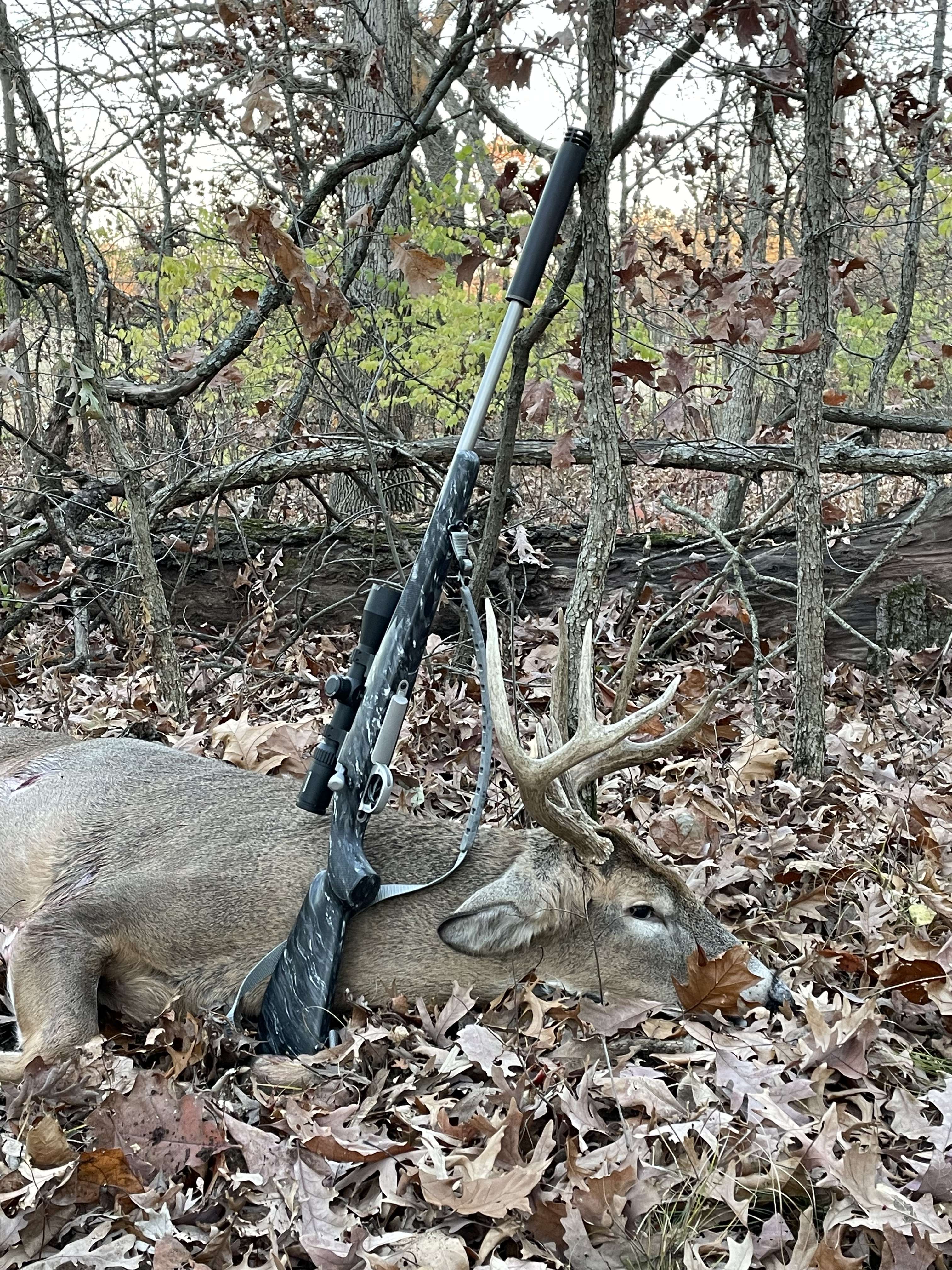
My view via a picture sent to me yesterday. Buck shot by my grandson in Missouri who turned 10 about a week ago. One shot at a lazered 320 yards. Son said that he thought it was a big bodied spike but it turned out its antlers were broken off. Grandson used a rifle I built for his dad.
Parker Hale M85 Build

Parker Hale M85 Build
Last edited:
Opening day did not dissappoint... got retarded but didnt disappoint. Shot a doe instead of the buck chasing her. I focused on the reticle not the lack antlers...


Went deer hunting, first time in the woods in the last three years... Dad's mental decline and cancer and passing are but memories now... didn't see much yet worth the effort. Shot pics instead.


Three days in the blind, numerous does and little guys that might be worth revisiting in a couple years. I did get an old rotted step replaced and a garage door fixed for my mom in between trips to the Blind. This used to be my play ground, now I am the care taker
Three days in the blind, numerous does and little guys that might be worth revisiting in a couple years. I did get an old rotted step replaced and a garage door fixed for my mom in between trips to the Blind. This used to be my play ground, now I am the care taker
Last edited:
Sorry for your loss. Spend as much time with your mom as you can.Went deer hunting, first time in the woods in the last three years... Dad's mental decline and cancer and passing are but memories now... didn't see much yet worth the effort. Shot pics instead.View attachment 8278339View attachment 8278340View attachment 8278341View attachment 8278342View attachment 8278343View attachment 8278344View attachment 8278345
View attachment 8278353
View attachment 8278346View attachment 8278347View attachment 8278348
Three days in the blind, numerous does and little guys that might be worth revisiting in a couple years. I did get an old rotted step replaced and a garage door fixed for my mom in between trips to the Blind. This used to be my play ground, now I am the care taker
That is the rear differential for a 340 case tractor. If you go back a couple of pages you can see the tear down of it
Yar…. I can’t decide if I be hunting or fishing, but the weather she be foul!

(Actually it stopped snowing / sleeting / raining, which is why I took the pic. “How’s it sit? Pretty cunning don’t ya think?”)
(Actually it stopped snowing / sleeting / raining, which is why I took the pic. “How’s it sit? Pretty cunning don’t ya think?”)
My wife bought herself a Jeep today. 2023 Rubicon diesel with 3 1/2 inch lift, Warne Zeon winch, 37 inch Nitto grapplers and some other goodies. 3600 miles on it. I may need to buy myself a bigger truck.

I've heard those diesels get good MPGs.My wife bought herself a Jeep today. 2023 Rubicon diesel with 3 1/2 inch lift, Warne Zeon winch, 37 inch Nitto grapplers and some other goodies. 3600 miles on it. I may need to buy myself a bigger truck.
View attachment 8281083
Don’t know about the smaller diesel in the Jeeps, but my 3.0 Dmax in a Yukon XL got 32 mpg on a short trip a couple weeks ago. I’m sure the Jeep close to that.
Apparently. I'm more interested in the torque though.I've heard those diesels get good MPGs.
Headed to visit daughter at JBLM while SIL is off in Japan

I’m stretching 27 on interstate if I drive sane.I've heard those diesels get good MPGs.
The jeep has a 3.0 turbo as well. Mine is the Overland. Has had its fair share of issues and time in the shopDon’t know about the smaller diesel in the Jeeps, but my 3.0 Dmax in a Yukon XL got 32 mpg on a short trip a couple weeks ago. I’m sure the Jeep close to that.
A few days ago but helped my brother diagnose a car at his shop. Always nice to go visit home. Did some backroad driving as well


Shadow of death visiting a Ford?A few days ago but helped my brother diagnose a car at his shop. Always nice to go visit home. Did some backroad driving as well View attachment 8290045View attachment 8290051
Nice 336, what caliber
Thanks. It is a .30-30, was made in 1975 and is in superb condition. I picked it up last fall.
I got a 35 Remington I use from time to time made in 1980Thanks. It is a .30-30, was made in 1975 and is in superb condition. I picked it up last fall.
Interesting month.... Hiked by the ruins of Palmer WV, plot was another 4 or so miles away..


Stuck at a training on lake Erie...


Stuck at a training on lake Erie...
Going to be wet!
I'm home to study today and this jerk keeps fighting his reflection in my windows.

Our cat and a seat in front of the window took care of that nonsense.
Dumb bird.
Dumb bird.
YepOur cat and a seat in front of the window took care of that nonsense.
Dumb bird.
Spent a couple days last week over at a buddies place putting this mobile shooting bench together. All of the metal, wheels, axels and wagon tongue came out of various scrap piles. The marine grade plywood was donated. The seats, jacks and aluminum box were the only things purchased.
Seats are on swivel bases so to access the right bench you just sit and spin….
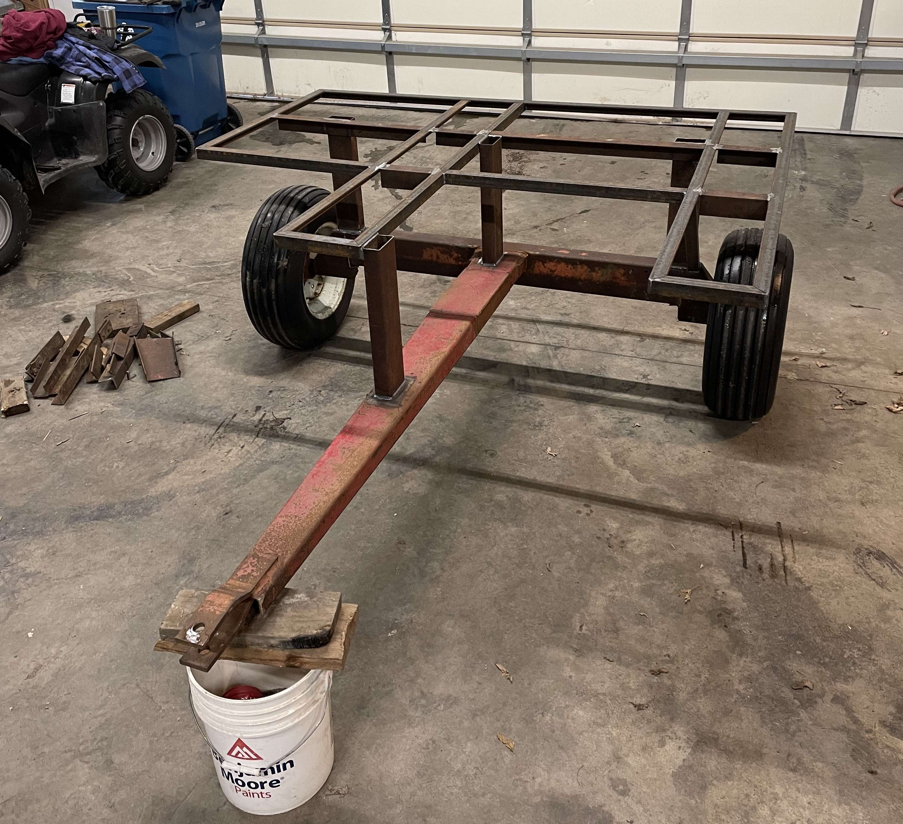
….a good start….
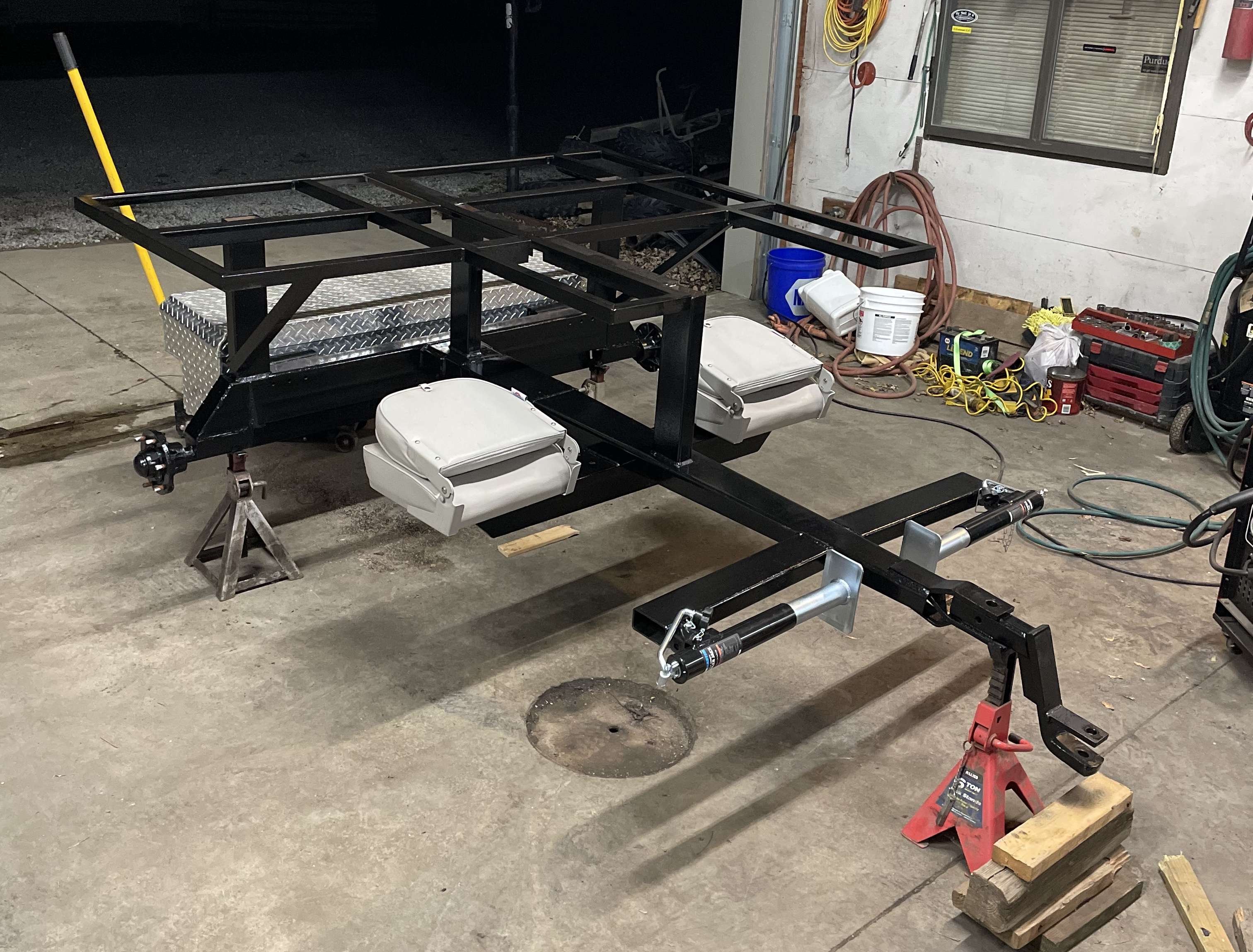
….metal work done and a coat of paint…
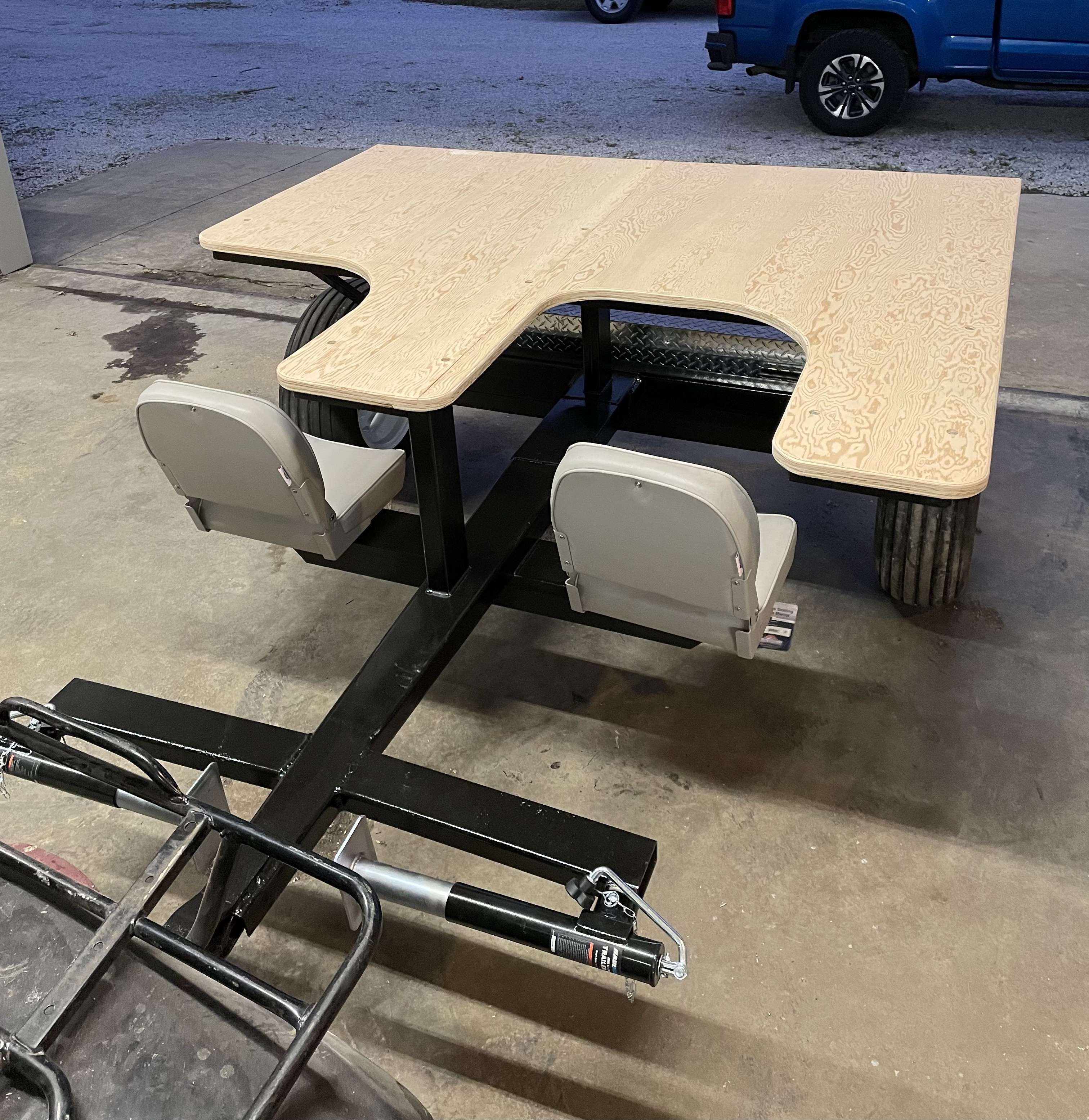
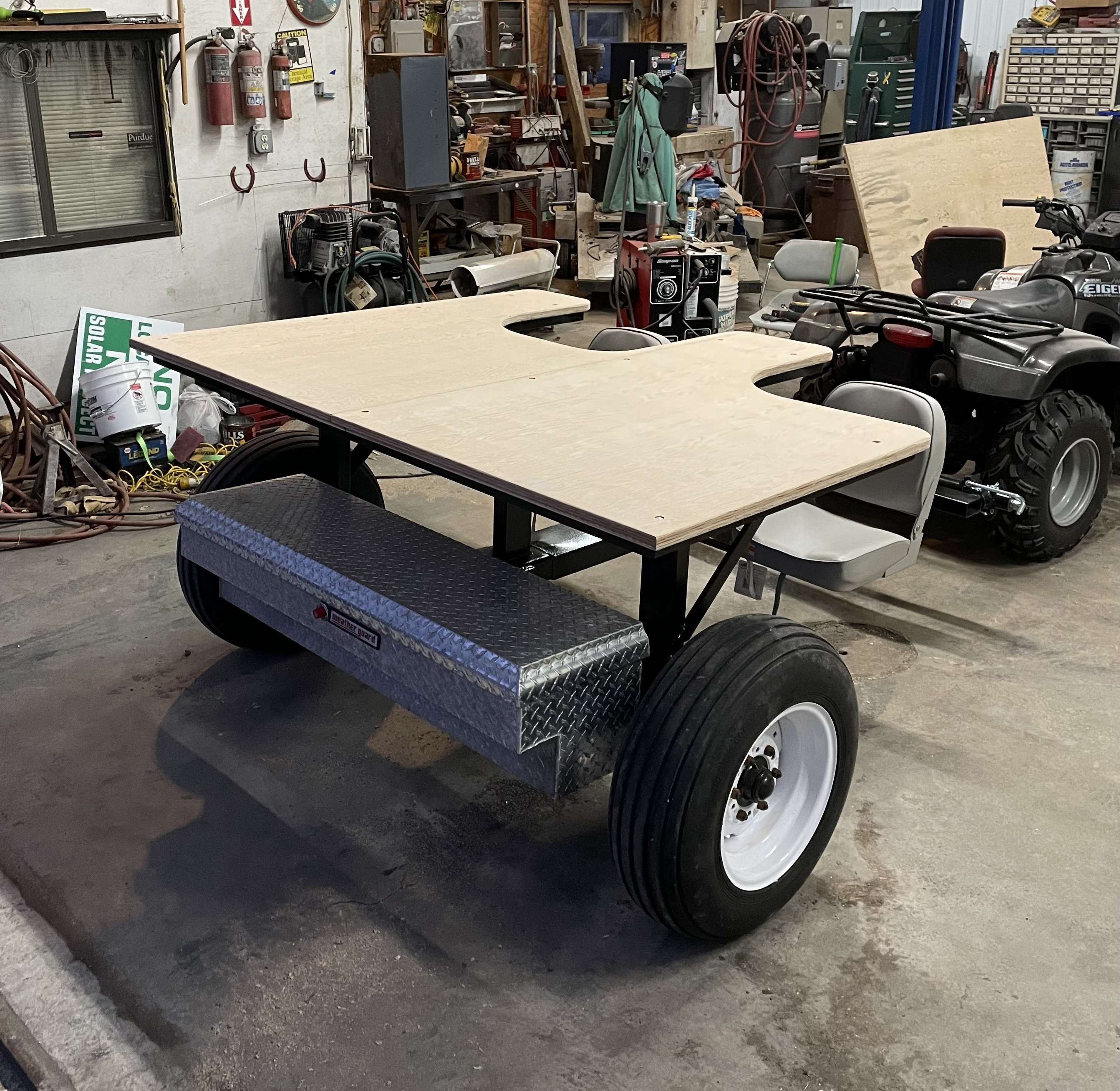
….got the top on, still needs some trim and finish. Plywood was a little damp so it’ll have to wait a week or two to dry out….
She’s a big girl, 80” wide by 64” deep…
Seats are on swivel bases so to access the right bench you just sit and spin….

….a good start….

….metal work done and a coat of paint…


….got the top on, still needs some trim and finish. Plywood was a little damp so it’ll have to wait a week or two to dry out….
She’s a big girl, 80” wide by 64” deep…
Last edited:
NiceSpent a couple days last week over at a buddies place putting this mobile shooting bench together. All of the metal, wheels, axels and wagon tongue came out of various scrap piles. The marine grade plywood was donated. The seats, jacks and aluminum box were the only things purchased…

….a good start….

….metal work done and a coat of paint…


….got the top on, still needs some trim and finish. Plywood was a little damp so it’ll have to wait a week or two to dry out….
She’s a big girl, 80” wide by 64” deep…
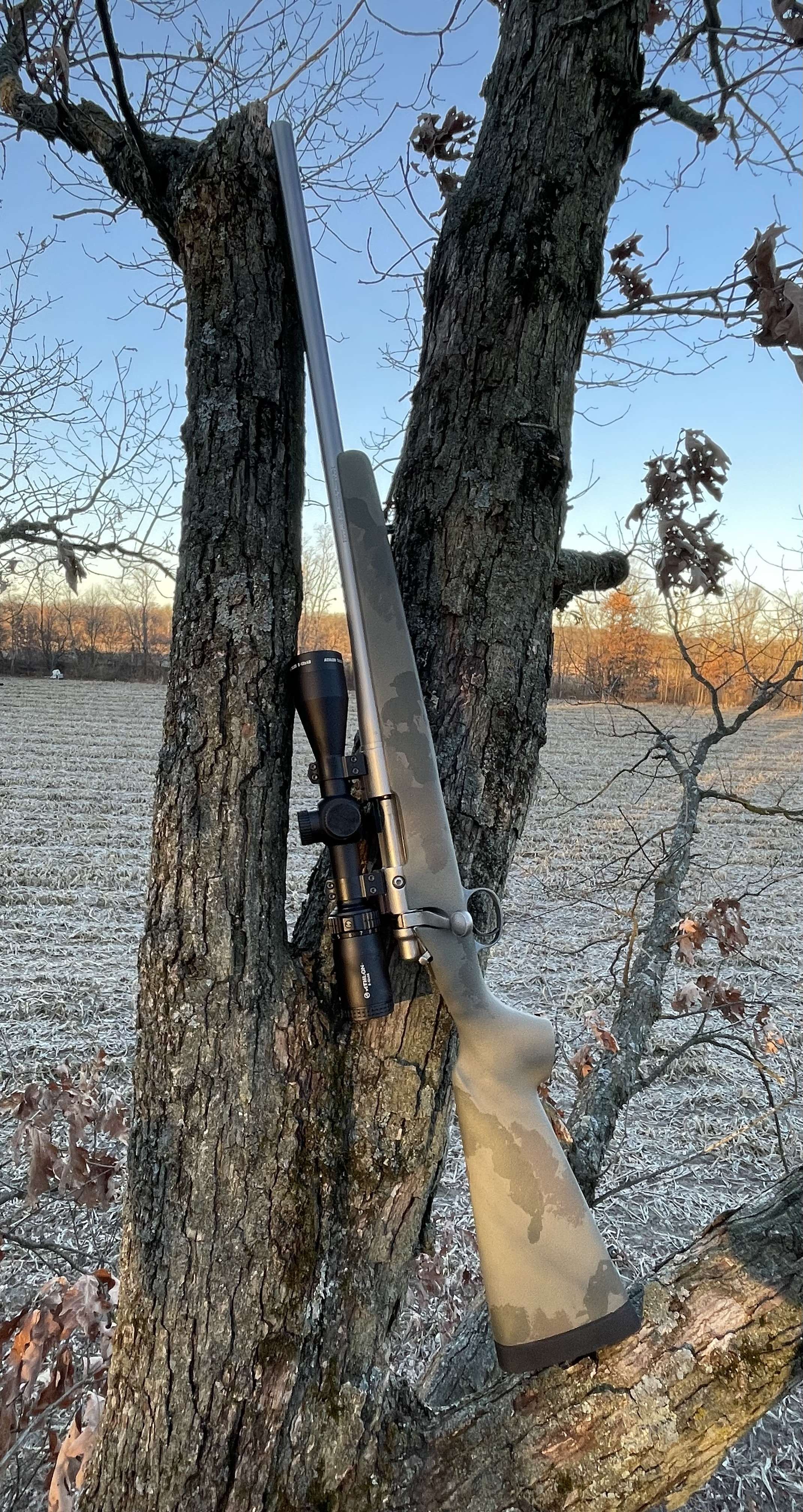
Beautiful morning only missing one thing…
Fucking awesome duet playing at our Christmas party

The quality of her pipes was only surpassed by the turd clippers on parade!

(Hey, it’s the Pit! LoL)

(Hey, it’s the Pit! LoL)
Quick pic of garage mahal progress OTW in to work last night… Screen for stucco is up, assume they’ll knock that out mañana, then rock work at some point this week. I hope.
Damn I’m ready for this project to be wrapped up.

Damn I’m ready for this project to be wrapped up.
For all the noise and banging around that kept me awake all dang day, it doesn’t look like a lot was actually accomplished.
They got most of the blocking up for the ‘ledge’ that will be at the bottom of the stucco, and top of the rock portion of the wall facings:

Kind of like this ledge on the end of the garage (and various places around the house), but at the 10’ mark instead of down low like this one:

Didn’t have time to see what else was done…if anything. Going on less than two-hours sleep; gonna be a fun shift.
Did I mention how ready I am for this project to be completed?
They got most of the blocking up for the ‘ledge’ that will be at the bottom of the stucco, and top of the rock portion of the wall facings:
Kind of like this ledge on the end of the garage (and various places around the house), but at the 10’ mark instead of down low like this one:
Didn’t have time to see what else was done…if anything. Going on less than two-hours sleep; gonna be a fun shift.
Did I mention how ready I am for this project to be completed?
Last edited:
I started tearing out uneven impossible to clean slate (with expanded metal in it on top of linoleum) in my kitchen. Found damaged subfloor next to sliding back door that was was easiest to fix by replacing and widening sliding door. Also tearing out carpet and putting in pergo with new base boards. Also replacing carpet on stairs with pergo. Doing it all myself.For all the noise and banging around that kept me awake all dang day, it doesn’t look like a lot was actually accomplished.
They got most of the blocking up for the ‘ledge’ that will be at the bottom of the stucco, and top of the rock portion of the wall facings:
View attachment 8300158
Kind of like this ledge on the end of the garage (and various places around the house), but at the 10’ mark instead of down low like this one:
View attachment 8300173
Didn’t have time to see what else was done…if anything. Going on less than two-hours sleep; gonna be a fun shift.
Did I mention how ready I am for this project to be completed?
Haven't finished drywall by sliding door, or started putting anything on stairs yet.
Started tearing out slate July 1st.
Will do a full better post later with pics once I get it done.
Similar threads
- Replies
- 20
- Views
- 1K
- Replies
- 22
- Views
- 1K
